Part of our Emergency Communications and Preparedness guide.
If you’ve spent any time in EmComm, SAR, or preparedness circles lately, you’ve probably seen the acronym ATAK thrown around next to phrases like “situational awareness” and “common operating picture.” It sounds military because it is military, but the civilian version has quietly become one of the more useful tools a prepared ham can carry. Here’s what it actually is, how it works, and where it does and doesn’t make sense to bring into your radio kit.
What ATAK and CivTAK Actually Are
ATAK stands for Android Team Awareness Kit. It started life as the Android Tactical Assault Kit, built by the Air Force Research Laboratory for use by special operations units who needed to see where their teammates were, share terrain and target data, and coordinate a mission without relying on radio chatter alone. It’s a moving map with a brain: your phone or tablet shows your own position, the position of everyone else on the network, and layers of shared information (routes, hazards, drawn lines, photos, chat) all overlaid on satellite or topo imagery.
CivTAK is the public release version of that same application, approved for distribution outside the military and available through the Google Play Store. The interface, the map engine, and the core feature set are virtually identical to the military build. A handful of classified or military-specific plugins are stripped out, but everything a civilian team needs (mapping, chat, position sharing, drawing tools, plugin support) is there. When people in the ham radio and preparedness world say “ATAK,” they almost always mean CivTAK.
ATAK and CivTAK sit inside a larger family called TAK, for Team Awareness Kit. TAK isn’t one app, it’s an ecosystem: a shared protocol, a family of client apps for different platforms, and server software that ties it all together. ATAK is the flagship, but it’s not the only door in.
How It Actually Works
Underneath the map, every device running a TAK client (called an EUD, or End User Device) is constantly generating small XML or Protobuf messages called Cursor on Target, or CoT. A CoT message is just a structured way of saying “this thing, at this location, doing this, as of this time.” Your own position is a CoT message. A pin you drop on a rally point is a CoT message. A chat message, a drawn route, a photo attachment, all of it moves as CoT.
Those CoT messages need a way to get from your device to everyone else’s. There are two common paths:
- TAK Server: A central server (self-hosted or in the cloud) that every EUD connects to over the internet or a local network. The server relays CoT traffic between clients, manages who’s allowed to see what, handles chat and file transfer, and keeps a record of the operating picture. This is how most organized teams run TAK.
- Peer-to-peer / mesh: On a local network with no server, ATAK clients can multicast CoT directly to each other over Wi-Fi. This is the mode most small field teams use out of the box, and it’s also the door that off-grid radio integrations (more on that below) walk through.
Because CoT is an open, documented protocol, almost anything can be taught to speak it. That’s the detail that makes ATAK interesting to hams: GPS trackers, ADS-B receivers, drones, weather stations, and yes, ham radio, can all be bridged into a TAK network as CoT sources, showing up on the map right alongside your team.
What It Actually Does
Strip away the acronyms and ATAK’s core feature set is genuinely useful for field operations of almost any kind:
- Blue force tracking. Every teammate’s position updates live on the map, with callsign, heading, and speed. No more “what’s your twenty” over the radio.
- Offline mapping. Download map tiles ahead of time (satellite, topo, street) and the whole thing works with zero connectivity once you’re in the field.
- Drawing and markup. Draw routes, boundaries, search sectors, and hazard zones directly on the map, and they sync to everyone connected.
- Chat and data packages. Text chat, file sharing, and pre-built “data packages” (a bundle of maps, markers, and instructions) that you can hand off to a whole team in one file.
- Sensor and camera integration. Pull in drone video feeds, ADS-B aircraft tracks, or trail camera photos as overlays.
- Plugin architecture. ATAK exposes an SDK, and a large community has built plugins for everything from ballistics calculators to (as we’ll get to) ham radio bridges.
What It’s Great For
The use cases that actually justify the learning curve tend to have one thing in common: multiple people moving independently who need a shared picture of where everyone is and what’s happening.
- Search and rescue. SAR teams use ATAK to assign and track search sectors in real time, so nobody duplicates ground or leaves gaps. The AFRL has even released a public search-planning plugin built specifically for missing person cases.
- Organized EmComm and CERT operations. A net control station or incident command post can watch field team positions and status without everyone talking over each other on the repeater.
- Group camping, hunting, and overlanding. Keep a convoy or group together without needing everyone glued to a radio, and drop waypoints for camps, water sources, or hazards that the whole group can see.
- Property and land management. Mark boundaries, gates, trail cameras, and infrastructure on a persistent offline map for a ranch, homestead, or hunting lease.
- Field day and POTA/SOTA group activations. Coordinate multiple operators or spotters across a large activation site without shouting across a field.
Where it’s overkill: a solo operator, a two-person team that can just talk on simplex, or anyone who isn’t going to put in the setup time. ATAK rewards teams, not individuals, and it rewards people willing to spend an afternoon in the settings menu.
The TAK Family: Similar Options Worth Knowing
ATAK isn’t the only client in the ecosystem, and depending on your platform or how much complexity you actually want, one of these might fit better:
- iTAK. The official iOS client. It covers maps, chat, and basic situational awareness, but it’s noticeably less mature than ATAK and doesn’t support the plugin ecosystem, so most of the ham radio integrations below aren’t available on it.
- WinTAK / TAKX. Windows-based clients aimed at command posts and desk operators. TAKX combines the older WinTAK with a more advanced mapping and mission-planning tool called RaptorX. Useful if you want a big-screen operating picture at a base station or net control desk.
- WebTAK. A browser-based client with no install required, good for a quick common operating picture on any device with a browser, though it’s less capable than the native apps.
- TAK Tracker / TAK Aware. Lightweight, send-only apps (Android and iOS) for team members who just need to appear as a dot on the map without running the full ATAK interface. Great for low-powered devices, dedicated trackers, or people who don’t want to learn the whole app.
On the server side, the official TAK Server is government software distributed through TAK.gov, which requires a vetted .mil, .gov, or industry-partner account. Most hobbyists instead run FreeTAKServer, a free, open source, Python-based server that’s fully compatible with ATAK, iTAK, and WinTAK and can run on anything from a Raspberry Pi to a cloud instance.
If what you actually need is offline topo maps and route planning rather than live multi-user tracking, tools like Gaia GPS or CalTopo will get you there with a much shorter learning curve. They’re not a replacement for ATAK’s real-time team awareness, but for a solo hiker or a two-person team, they’re often the better fit.
How ATAK Ties Into Amateur Radio
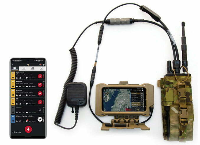
None of this requires a radio at all, ATAK will happily run over Wi-Fi or cellular data. What makes it interesting to hams is that the CoT protocol is open enough that several projects now bridge it onto amateur gear, letting a TAK picture stay alive when there’s no internet or cell service at all.
- APRS bridges. Tools like APRS-TAK and aprstak listen to the APRS-IS network or a local TNC and convert APRS position reports into CoT, so any station beaconing APRS shows up as a live position on the ATAK map, and vice versa. This is a natural fit if you’re already running APRS through an HF or VHF digital setup.
- Meshtastic integration. The atak-forwarder plugin bridges a Meshtastic LoRa mesh directly into ATAK, so everyone carrying a cheap Meshtastic node shows up on the map with no cell or internet infrastructure at all. This pairs well with the mesh limitations we cover in our look at off-grid Meshtastic and LoRa comms, since ATAK gives that mesh data somewhere useful to live.
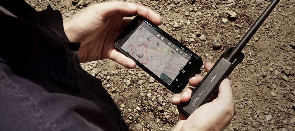
- Purpose-built mesh and MANET radios. Meshtastic isn’t the only mesh hardware that talks to ATAK, it’s just the cheapest. goTenna Pro X and X2 ship an official ATAK plugin that pushes PLI, chat, and points over their own mesh protocol, and it’s a common off-the-shelf option for teams that want mesh radios without building anything themselves. Beartooth’s MK II is a similar self-forming mesh radio with its own ATAK plugin, adding push-to-talk voice on top of location and text. Hytera’s commercial DMR handhelds get their own ATAK bridge too, the HyTAK plugin pairs over Bluetooth and sends position, chat, and markers over the radio’s existing digital channel, no internet required. At the high end, Persistent Systems’ MPU5 runs a proper MANET (Wave Relay) rather than a LoRa mesh, ships with ATAK pre-installed, and is built for teams that need real throughput for video and data, not just position beacons. None of these are ham gear or ham bands (they run on ISM or licensed commercial spectrum, not the amateur bands), but they show up in the same conversations as Meshtastic because they solve the same problem: getting a TAK picture to work with no cell or Wi-Fi around, just at a higher price and capability point. If you want to see what off-the-shelf ATAK-ready hardware actually looks like, GoTAK’s radio and mesh comms catalog is a decent one-stop look at current options across this whole category.
- Analog voice radio (HAMMER/ARIK). An open source plugin that encodes CoT data as an audio tone burst and transmits it over an ordinary analog radio, including cheap handhelds, letting basic position and status data ride over a plain FM channel with no data mode or internet required.
- Off-grid TAK servers. Some teams run FreeTAKServer on a laptop or Raspberry Pi at a base station, with field units bridging into it over APRS, Meshtastic, or an AREDN mesh link, keeping a full team picture alive well outside of cell coverage.
One legal point worth being direct about: if you’re moving CoT data over amateur frequencies, it’s still amateur radio, and Part 97 still applies. TAK Server connections normally use TLS encryption and client certificates, which is fine over the internet but is not legal to transmit over ham bands, since Part 97 prohibits messages whose meaning is obscured. The APRS and Meshtastic bridges above work because they’re moving plain, unencrypted position and status data, not because TAK’s encryption is somehow exempt. If you’re bridging ATAK onto ham gear, keep that link unencrypted and treat it the same as any other digital mode on the band.
Getting Started
- Install CivTAK from the Google Play Store (search “ATAK” or “CivTAK”). It’ll run on most modern Android phones and tablets; a Samsung Galaxy or similar mid-range device handles it comfortably.
- Download an offline map package for your area before you head out. ATAK ships with no maps by default.
- For a small group, start with peer-to-peer mode over a shared Wi-Fi hotspot before you bother standing up a server. It’s the fastest way to see the app actually working.
- Once you outgrow peer-to-peer, spin up FreeTAKServer on a spare laptop or a Raspberry Pi and connect your team’s devices to it over the internet or your own network.
- Budget real time to read the settings menu. ATAK’s biggest usability problem isn’t the map, it’s the sheer number of options buried in menus that aren’t self-explanatory.
The Honest Trade-Offs
ATAK is not a polished consumer app. The interface is dense, the settings menu is enormous, and the learning curve is real; expect to spend an evening or two just finding your way around before it feels natural. It also assumes a team, if you’re operating solo, most of what makes ATAK worth the effort simply doesn’t apply. And while CivTAK is publicly available, the plugin ecosystem is split: some of the best plugins are open source and free for anyone, while others (particularly government-developed ones) require a vetted TAK.gov account you likely won’t qualify for as a civilian.
None of that makes it a bad tool. It makes it a tool worth trying with a group before you build your whole preparedness plan around it, the same way we’d say about any tactical comms tool that promises more than a radio alone can deliver. Get it running on a couple of phones during a hike or a Field Day setup, see if your team actually uses the shared picture, and go from there.